
Sugarloaf Ridge Hiking
Sugarloaf Ridge is home to some of the finest hiking and views you’ll find in the North Bay. On a clear day, the views from the top of Bald Mountain (elevation 2,729 feet) are magnificent and include the Sierras to the East, San Francisco Bay and Mount Diablo to the South, Mount Tamalpais to the South-West, the Coastal Range, and the Pacific to the West and Mount Saint Helena to the North. The park is home to the headwaters of Sonoma Creek including a 25-foot seasonal waterfall.
- Hiking Guide
- Family Hikes
- Extended Hikes up to 3 hours
- Extended Hikes 3+ Hours
- Sunset Hikes
- Accessible Hikes
| If you… | Choose |
|---|---|
| Need Accessibility | Meadow Trail |
| Have About 1 Hour | One of the Family Hikes |
| Have up to 2 Hours | Vista Trail Loop |
| Have 3 or More Hours | One of the Extended Hikes |
| Want to See a Waterfall | Canyon-Pony Gate Loop |
| Want a Self-guided hike | The Nature Trail or the Quest Hike |
Family Hikes with Guides
- Creekside Nature Trail: 1 mile. Easy, shaded. Get a trail guide at the Visitor Center or trailhead. Park in the main lot, cross the road and follow the Nature Trail adjacent to the creek. Loop through the campground. 30 minutes. Nature Trail Brochure.
- Meadow-Hillside Loop: 2 miles. Easy/moderate, 250-ft elevation change. Enjoy views, stream crossings, and forested hillsides. Start at the Observatory, follow Meadow Trail and Planet Walk, then return via Hillside Trail. Meadow has 80% sun exposure. Hillside is mostly shady with views. 1 hour. Wildflower Scavenger Hunt Brochure.
- Canyon-Pony Gate Loop: 2 miles, moderate, 500-ft elevation change. Experience shady forests, towering redwoods, and a seasonal 25-foot waterfall. At the lower Canyon trailhead, go up the road a few yards to Pony Gate Trail or begin on the upper Pony Gate trailhead and loop up on Canyon Trail. 1 hour. Getting to the Waterfall.
- Quest Hike: 1.4-1.9 miles. Easy, 50% shade. 80-ft elevation change. Follow rhyming clues to find the path and learn about park features. Prize at the end! Look for the treasure box when you get back near the start. Begin at the main day-use lot on Lower Bald Mountain Trail. 1 to 1.5 hours. View/print a Quest Hike Brochure.
- Fire Recovery Walk: 1.8 miles. Moderate. 350-ft elevation change. Learn about fire’s effects on vegetation. Get a guide at the Lower Bald Mountain trailhead. Head up Lower Bald Mountain to Bald Mountain Trail. 1 hour. Fire Recovery Walk Guide.
- Planet Walk Loop: Explore the planets in relative distances, starting at the Sun near the Robert Ferguson Observatory. Guide maps are available at the Visitor Center or Observatory. Take the Meadow Trail for this hike. Planet Walk Guide.
- Easy (Sun through Saturn): 2.2 miles. 200-ft elevation change. After Saturn, continue on Meadow to Hillside Trail, then follow Hillside back to start. 1 hour.
- Strenuous (Sun-Pluto): 5.3 miles. 1100-ft elevation change. Take the Meadow Trail and turn left onto Brushy Peaks. You can reverse back at Pluto or continue to Gray Pine and return. 2.5 hours.
Extended Hikes up to 3 Hours
- Vista Trail Loop: 4.1 miles. Moderate. 600-ft elevation gain. 70-90% sun exposure. 2 hours.
Take Stern Trail or Lower Bald Mountain, turn right on Bald Mountain Trail, right on Vista Trail, right on Gray Pine Trail (seasonal creek crossing), and continue on Meadow Trail to return to the main parking lot. Reverse for a shadier climb. Great flowers and views. - Bald Mountain: 5.6 miles. Round trip. Moderate-strenuous. 1,529-ft elevation gain. 70-90% sun exposure. 3 hours.
- Take Stern Trail or Lower Bald Mountain Trail, turn right on Bald Mountain. At the top, enjoy magnificent views. Reverse to return.
- Bald Mountain Trail to Red Mountain/Headwaters (Short Version): 5.3 miles, Moderate. 2.5 hours.
Take Stern Trail or Lower Bald Mountain Trail. Turn right on Bald Mountain Trail. Turn right on Red Mountain Trail, well before the summit (this is the first Red Mountain Trail sign and is off the Bald Mountain Trail). Turn right on Headwaters Trail. Slight left on Vista Trail. Turn right on Gray Pine Trail (seasonal creek crossing). Turn right on Meadow Trail or stay left another .05 miles and then turn right on Hillside Trail (seasonal creek crossing). - Brushy Peaks to the Picnic Table at Neptune: 5.2 miles. Moderate. 900-feet elevation gain. 35% sun exposure. 2.5 hours.
Start with the Creekside Trail, then continue to Hillside and finally to Brushy Peaks Trail. Stop at the picnic table shortly after Neptune on Planet Walk. You can return the same way or via Meadow Trail for a shadier option. There’s a seasonal creek along the way. - Planet Walk Loop: 4.5 miles, Easy (Inner planets) to Moderate (Uranus-Pluto) – 2.5 hours for the full loop.
See the Planets in the relative distance and start at the Sun near the Robert Ferguson Observatory. Take Meadow Trail. Turn left on Brushy Peaks. There is a picnic table after Neptune, follow through to Pluto. Reverse to return or continue on Brushy Peaks, turning left on Gray Pine Trail to make a loop back to Meadow Trail. Total elevation gain 1,100 feet. - Goodspeed Trail to Park Boundary: 2.1 miles one way (4.2 miles round trip). Moderate. 900-feet elevation gain. 50% sun exposure. 2 hours.
Follow the Goodspeed Trail to the bench, located 0.2 miles beyond the park boundary with Hood Mountain Regional Park. Backtrack to return to the parking lot.
Extended Hikes 3+ Hours
- Bald Mountain Loop: 6.6 miles. Moderate-Strenuous. 1,529 feet elevation gain. 70-90% sun exposure. 3.5 hours. Take Stern Trail or Lower Bald Mountain Trail. Turn right on Bald Mountain Trail. At the top you will have magnificent views in all directions. After the summit, turn right onto Gray Pine Trail (be careful not to take High Ridge Trail) (seasonal creek crossing). Turn right on Meadow Trail or stay left another .05 miles and then turn right on Hillside Trail (seasonal creek crossing).
- Bald Mountain Summit Loop with Red Mountain and Headwaters Trails (Long Version): 7.4 miles. Moderate-strenuous. 1,529+ ft elevation gain. 60-80% sun exposure. 4 hours. Follow directions for Bald Mountain, then take Gray Pine Trail, turn right on Red Mountain Trail, left on Headwaters Trail, right on Vista Trail, and left on Lower Bald Mountain or continue to Stern Trail and turn left.
- Bald Mountain to the Red Barn: Old Homestead. 8.8 miles. Strenuous. 2500 feet elevation change. 70-90% sun exposure. 5 hours.
Take Stern Trail or Lower Bald Mountain Trail. Turn right on Bald Mountain Trail. Turn left on High Ridge Trail for 1.4 mi. Turn around at Red Barn. This is the end of State Park property. Do not trespass beyond the boundary. Return using Bald Mountain Trail. - Bald Mountain to Brushy Peaks Trail (The Big Loop): 8.2 miles. Strenuous. 2000 feet elevation gain. 70-90% sun exposure. 5 hours.
Brushy Peaks features steep dirt trails (40%+ grade) – use hiking poles for support! To reach Brushy Peaks, take Meadow or Hillside Trail. Continue straight (or right) onto Gray Pine. From the summit of Bald Mountain, follow Bald Mountain Road to Lower Bald Mountain Trail. - Goodspeed Trail to Gunsight Rock & Hood Mountain: 7.5 miles round trip. Strenuous. 2000 feet elevation gain. 4 hours.
Take Goodspeed trail from the lower parking lot. Take the Goodspeed Trail, which becomes Nattkamper Trail after 2.1 miles as it crosses into Hood Mountain Regional Park. After 1.2 miles, turn left and hike for 0.2 miles to reach Gunsight Rock, which offers stunning views of Sonoma Valley. Hood Mountain summit is 0.2 miles straight ahead. No views from Hood Mountain Summit.
Sunset Hikes
- Shortest: Take Hillside Trail from the White Barn Parking Lot; trailhead starts near the ADA parking spot. After crossing the creek, turn left up the hill till you get to the picnic tables. 0.3 miles each way. 200-foot elevation gain.
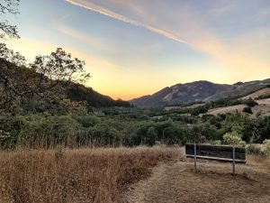
Camp Butler Sunset
- Medium: Take the Nature Trail from the main day-use parking lot. Once you connect with Hillside – go uphill until you get to the picnic table at Camp Butler. 0.75 miles each way. 200 foot elevation gain.
- Long: Take Meadow Trail from the Observatory. Stay Right as it becomes Hillside Trail. After about 1.7 miles, you will come to Camp Butler, just after the water tank. 2.0 mile loop. 230-foot elevation gain.
- Camp Butler: Great views of the Valley and Hood Mt.
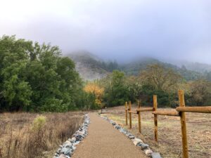
Accessibility on Sugarloaf Trails
The Nature Trail is a .5 mile (one-way) ADA trail. It starts from the main day-use parking lot and goes to the white barn parking lot. ADA parking is located at each end.
The Meadow Trail is a gravel fire road that leads to a stream and is used as a trail by hikers, bikers, and equestrians. It is not ADA certified, but it is generally passable by most wheelchairs. It may be accessible for about 3/4 miles. Occasionally gravel works loose and limits accessibility. The trailhead is approached from the white barn parking lot and the observatory.
Restrooms: Wheelchair-accessible restrooms available at:
- The Visitor Center (porta-potty)
- Main Day Use Parking (vault toilet)
- Observatory/Group Camp (porta-potty)
- Campground Main Restroom (flush with sink)
Parking: Van Accessible ADA parking available at the Visitor Center, Main Day Use Parking Lot, and the White Barn Parking.